“for ’tis I that exacted a singular vow, such as no woman before me had ever required of a man of the men of Erin, namely, a husband without avarice, without jealousy, without fear.For should he be mean, the man with whom I should live, we were ill-matched together, in as much as I am great in largess and gift-giving, and it would be a disgrace for my husband if I should be better at spending than he, and for it to be said that I was superior in wealth and treasures to him, while no disgrace would it be were one as great as the other. Were my husband a coward,’twere as unfit for us to be mated, for I by myself and alone break battles and fights and combats, and ‘twould be a reproach for my husband should his wife be more full of life than himself, and no reproach our being equally bold. should he be jealous, the husband with whom I should live, that too would not suit me, for there never was a time that I had one man in the shadow of another.’
Medb speaks during the Pillow Talk, the opening chapter of the Táin Bó Cúailnge.
Queen Medb (Maeve in English), the legendary Queen of Connacht in Irelands great epic the Tain Bo Cuailnge (The Cattle Raid of Cooley) is one of Irelands best known goddesses. The archetype of the warrior Queen, she looms large in the mythology of Ireland, and especially Connacht. She was said to have cohabited with nine kings of Ireland. Medb demanded her husband satisfy her three criteria—that he be without fear, meanness, or jealousy, and we will see later what these demands really mean.
The Tain of course begins with the story known as the Pillow Talk between Medb and her husband Aillil, in which upon comparing their respective wealth she discovered her possessions were not entirely equal to her husband. Discovering that she had no bull to match that of her husbands white bull Finnbheannach (white horned), she set out to get the only one in Ireland that could match it, the Brown Bull of Cooley, for she could not be anything other than equal to her husband in wealth. When it was refused to her, she launched the invasion of Ulster to acquire it. And so the tale begins.
What is perhaps less known though are the deeper origins of her name and connection to rituals of kingship, wealth, sovereignty and the female energy in nature, not only in Ireland, but also in India, the easternmost part of Indo- European culture.
The Tain is set traditionally around the time of Christ in western calendars, but it is evident that in her guise as a goddess she is far, far older than that.
Medb as we Know Her
The spelling in Old Irish is Medb, a name derived from an ancient Indo-European word Medhu, meaning mead, the alcoholic drink made from honey. “She who intoxicates” would be a fair translation of the meaning of her name. And indeed in the tales she is not averse to using her sexuality to get what she wants, offering many heroes her “friendly thighs” on top of other rewards in exchange for fighting Cuchulainn, a deal that almost always resulted in their death.
A ritual drink was given to Irish kings when they were inaugurated. This ceremony was conceived as a marriage between the king and his territory. For example in the Annals of Loch Ce, it says that in 1310 Feidhlim son of Aedh “married the province of Connacht”. Similarly, it was part of every marriage ceremony for the bride to offer a drink to the husband to symbolise their consent to the union.
In this way Medb symbolised the land and a kings sovereignty over it. Many stories involve meeting a hag who is transformed into a beautiful woman through a kiss or sexual union. Niall of the Nine Hostages was said to have acquired the kingship this way as he was the only one to kiss (and indeed lay down with!) a hag guarding a well, upon which she turned into a beautiful woman and revealed herself as the Sovereignty of Tara, and that Niall and his descendants would have it forever. This hag is likely an incarnation of Medb, and is known as Flaith, a word meaning “power”.
Medb, the goddess of sovereignty at Tara was known as Medb Lethderg, meaning Maeve of the Red Side and it is liokely that she is the goddess in this story. Rath Medb is a large enclosure (750 feet across) to the south of the hill of Tara associated with her, however it is much neglected..
Once a king had accepted marriage to the goddess, he was bound to respect the land as his wife. Therefore to spoil or defile it meant that the Goddess would break that bond and remove her protection, a fearsome injunction indeed.
As the Tain unfolds many places acquire names from notable events involving Medb, such as where her pet stoat is killed by Cuchulain and the incident is commemorated by naming the p[lace after it. In this way many landforms are associated with her, which, as a goddess representing the land, makes sense.
She is associated in Connacht with Rathcroghan, a vast ritual complex near Tulsk in Co. Roscommon where the kingship of Connacht was based from ancient times until the 17th century. Here, her name appears in an Ogham inscription at the entrance to the cave Uaimhe na gCait, the Cave of the Cats, reputed to be an entrance to the underworld. In some stories she incarnates as a fawn.
Ireland or Erin was, and is, divided into five provinces, hence the name in Irish coiced, or fifths. Each province was ruled by a king or provincial king and the over-king was the ruler of the central province, Mide (Meath).
Due to the Christianisation of Irish mythology and the old religion, the divine aspects of Medb were downplayed, and she was pictured more as a queen in the human sense. However, enough survives in the stories for us to reconstruct what she must have originally represented, and when we compare them to her counterparts in Indian mythology we can see that there is much more to Medb than meets the eye.
Lakshmi, Madhavi and Medb
The Indian Mahabharat is one of the great epics of ancient Indian culture. Written in Sanskrit, the story in its present form goes back to the 4rth or 5th century BC, but contains material that is much older, dating back to the time of the Vedas the oldest layer of Indo-Eropean literature to survive in the world, dating back three or four thousand years ago.
Shri Lakshmi Goddess of Wealth and Sovereignty
Medbs counterpart in Indian mythology is found in the story of Madhavi, a name that also derives from Medhu meaning mead. She is an earth goddess in Indian mythology, and this name is also one of the names of the goddess Lakshmi the goddess of wealth, fortune and prosperity. In the ancient scriptures of India, all women are declared to be embodiments of Lakshmi. She is the consort of Vishnu and the marriage and relationship between Lakshmi and Vishnu as wife and husband is the paradigm for rituals and ceremonies for the bride and groom in Hindu weddings. In an early form Sri (later combined with Lakshmi), the wife of Indra, offers him a drink of soma, a fermented drink of the gods. So here we have an echo of the connection between Irish kingship rituals as a marriage to the goddess Medb, and Irish weddings and the importance of ritualised drinks.
Lakshmi is the goddess of wealth, fortune, power, luxury, beauty, fertility, and auspiciousness. When worshipped as Maha-Lakshmi, Lakshmi is visualised as a warrior-goddess riding a lion. Lakshmi is associated with horses and cattle, both symbols of wealth and it is in this guise as the bestower of wealth, power and sovereignty that we may recognise the very same elements in the character of Medb. The reason we know they are connected is in the survival of this remarkable ancient story in the Mahabharat about Madhavi, a lesser known version of Lakshmi in Indian culture.
In this very ancient story a sage called Galavi asks his guru repeatedly for his price for teaching him, the guru responds in irritation that he will take 800 white horses, each with one black ear. A seemingly impossible request! So Galavi goes to the greatest king at that time Yayati, who says he does not have the horses, but gives him his daughter Madhavi instead. Her beauty was so striking that any king would gladly give up his kingdom for her, and they are described as lusting after her. She has the ability to have a child and become a virgin again afterward and she tells Galavi that this is how she can solve his problem. So Galavi goes in turn to three kings who are childless and gets 200 horses from each one in exchange for them having a son with Madhavi. He then returns to his guru with the 600 horses and offs him Madhavi in exchange for the final 200 horses that he is short. She has a fourth son with the guru. the sons become the founders of dynasties, and the land is divided up amongst them.
The story is very old, its principle characters come from the distant Pre-Vedic or early Vedic times. The parallels to the Irish Medb are striking. In both cases there is a theme of procuring rare and precious animals, both are embodiments of female sexual power and use their sexuality to attain a goal, both marry kings repeatedly, and are evidently seen also as the embodiment of sovereignty. Madhavi is not sovereign herself; but sovereignty passes through her to her four sons who grow up to become great kings whose deeds are celebrated in the Puranas. In Medbs case, it is her demands of a husband that tell us the qualities that an Irish king must have. To be without fear, to be generous, and to be without jealousy are the qualities required to marry her, in other words to become a king. And hence men who compete for the kingship are seen to be vieing with each other to marry her, and their qualities or lack of them determine the outcome, with many of them dying in the process. The balance that is aimed for is the combination of the female energy of the land married to the male energy of the king. When these are in balance, then the rule will be harmonious.
Furthermore, Madhavis father, Yayati, divided his kingdom (which was the earth) among his five sons: to Tuvasha he gave the south-east; to Druhyu the west; to Yadu the south and west; to Anu the north; and to Puru the centre . Purus ruled as the Supreme Kings of earth. This has obvious echoes of the five divisions of Ireland into north, south, east, west and centre, with the centre being the location of the supreme king.
The similarity in stories from the extreme east and west of the Indo-European world is fascinating and shows the age of the concepts underlying these tales goes back to the beginning of the cultures emergence. The Tain is therefore built around themes that go back at least to the Bronze Age, and perhaps further, certainly to the first arrival of Indo-European speaking people in Ireland. The provinces must be similarly ancient, based as they are on an idealised ritual version of how the universe and land should be organised which is shared in India. We cannot date it exactly, but the time of last contact between Indian and Irish populations may go back to the 4th or 5th millenium BC, and arrival in Ireland in the 3rd or 2nd millenium BC, which shows the depth of time we are talking about in these tales.
Does a Goddess Ever Die?
In so far as goddesses can die, Medb of the Tain was said to have been killed on an island called Inis Cloithreann (Clothru seems to be a synonym for Medb) in Lough Ree near Knockcroghery while bathing. She was killed by Furbaide in revenge of his mothers death by a piece of cheese fired from a sling. It is likely though that the story of her death is a later concept, when her divine nature was less popular and the stories had become secular in meaning. No longer worshipped as a goddess directly, she now became known only as the warrior queen of Connacht, which was more acceptable to the Christian world.
While she is associated with many sites in Connacht, she is generally believed to have been buried in the great cairn on Knocknarea in Co. Sligo. The cairn is called Miosgain Medb, meaning Maeves butter pat, from its resemblance to the shape of a traditional pat of butter. That she is reputed to be interred here is interesting as her association with kingship may mean that this is a burial place for kings, and there is reason to believe that the west is where the souls of the dead journeyed to the underworld. However, there is no mention of her association with the cairn in ancient Irish texts and therefore it may be a later folk belief or comes from the habit of naming landforms after her.
Nowadays, interest in her has been revived in Ireland with the rise of neo-pagan religions and particularly in relation to female sexuality. Irish and Irish-American poets have explored Medb as an image of woman’s power and sexuality, as in “Labhrann Medb” (“Medb Speaks”) by Irish-language poet Nuala Ní Dhomhnaill. Appropriate in a time where women are only now achieving equality comparable to that which had been the norm in Ireland in times past. However, when we look at the full depth and range of associations that Medb has with ancient concepts of the land, fertility, wealth, authority and so on across the world, we can see that she is a very important key in recovering lost aspects of Irelands heritage, especially when it comes to womens story on this island. The old scholars may have Christianised much of Irelands ancient literature but, uniquely in western Europe, they preserved it in its essence also, which gives us something precious, a window into the sophistication, colour and drama of ancient Irish culture, comparable to anywhere in the world.
Postscript
Perhaps it would also be no harm if the principles of kingship and the contract between rulers and the land that Medb represented for so long were also revived, considering the poor state of modern Irish political leadership and its sad disconnection from both the land, and the high principles that were once expected of, and enforced, upon Irish leaders by the goddess herself, Medb.
Notes
M L West, Indo European Poetry and Myth.
A prayer fragment on Lakshmi showing the three aspects of female life that Medb also sometimes appeared in.
“Every woman is an embodiment of you. You exist as little girls in their childhood, As young women in their youth And as elderly women in their old age.”
Despite success in raising living standards in Ireland since independence, and especially since joining the EU in the early seventies, Irish governments have failed to prevent the imbalance of development in Dublin at the expense of almost every region in the country. Emigration has remained a preferred solution to economic downturns, with the forcing of young people abroad by the cutting of social welfare payments for the under 24s. One in five Irish people now live abroad, the highest percentage in any OECD country, (there are 34 of them) Poverty and decline across what is termed “rural Ireland” remains endemic. Over large parts of the country, infrastructure continues to be less than it was in the 19th century under the British Empire. In the 1990s the train to Sligo was slower than it had been in the 1890s.
All cities draw migrants from their hinterlands, but when that becomes the only choice in an entire country then there is a problem. drawing the people to Dublin is then a form of exploitation, and does not in fact do Dublin any favours either as one third of the national population now resides in the environs of the capital., putting its infrastructure, resources and quality and standards of living under severe pressure. the current housing crisis is a good example of this extreme imbalance.
History of Over Centralisation
The colonial history of Ireland has left indelible marks on the country that we are still struggling to deal with. Ireland is perhaps the most centralised state in Western Europe. Few countries have weaker regional representation, power and government, nor are any, quite as democratically insignificant as in the Irish case.
The first point to make is that Dublin has only been the independent capital of Ireland for just over 90 years since 1922. Before that it acted as the centre of power for the British administration, effectively under the supervision of Westminster and the Crown. Prior to that, it was an outpost within the Pale of English culture, a foothold that had survived since the Norman invasion of 1169. Before that again it was of course a Viking trading centre and slave market tolerated by the Irish kings as long as it paid its dues.
For most of these centuries, the lands beyond the Pale fence were regarded as hostile and barbarous. Often a tax was paid, known as the Black Rent, to Irish chieftains in exchange for peace. For a thousand years, Dublin was an outpost in a foreign land. The psychology of this long history of division is evident to this day in the divide between the “city” and “rural Ireland”. Rural Ireland is the modern euphemism for the wild lands beyond the Pale, except now it is less a geographical reality, but a psychological one, existing in the minds of Irish people. It is little wonder Dublin has little tradition of acting in this role with full confidence of how to do it effectively, evenly and with benefit to the whole country.
But the colonial mindset did not go away. No reform happened after the Free State was established. In fact, the tendency towards centralised control established under Imperial conditions was exacerbated with the weakening of even the British created local democracy after the civil war because it was feared by the insecure Free State that anti-treaty councils would be uncontrollable, therefore the centrally appointed executives (county managers) were made more powerful than the elected council. A situation that continues to this day.
On the other side, the alienation of Irelands regions stems from the same history. Disconnection from what was, after all, an alien system imposed by the British through Dublin was the norm from the late 16th century onward. This means there is little sense of ownership and rights to self determination at a regional level. Instead, people are elected in the hope that when they go to Dublin they may wrest favours from the system. This has kept clientelism alive and well, with dynasties inheriting the role of spokesman for the areas by default.
Even after engagement with the EU, which requires strong regional structures to create balanced development, Ireland has continued to resist the devolution of meaningful power to the regions. Preferring to set up unelected quangos and boards that are centrally appointed. There are no directly elected provincial or regional authorities between central government and the local authorities in Ireland. The eight regional assemblies that do exist are so weak and uninfluential that most people have never heard of them. The maze of entities and overlapping bodies means no-one has a clear idea of how anything works, or how to get anything done.
Instead of services being delivered by local councils, a multitude of executive agencies has been created, like Irish water and Transport Infrastructure Ireland, which consist of unelected professionals only and are therefore out of localised regional control. Even cases of supposed “decentralisation”, where government departments have been moved to regional centres is not true decentralisation. For that to be the case, power would have to delegated to these centres as well, but that is not the case. It remains firmly entrenched in Dublin.
So, almost all regional activities of the state are organised centrally and delivered in a “top down” model imposed on communities across the country. Direct applications for project funding to Europe from Irelands regions are not allowed, instead, they are routed through Dublin first for approval or alteration. This is not the norm across Europe, and neither has it been successful. For example, in the Border, Midland and Western (BMW) region funds earmarked were under-spent by 59 per cent and under 20 per cent in some seven measures (just 4.6 per cent of spending forecast for regional innovation and 1.2 per cent for waste management had been spent up until 2002. Vast sums of EU money has had to be sent back as projects could not be found for it. An astonishing fact considering how underdeveloped much of Ireland still is.
Furthermore, plans are changed on an ad hoc basis depending on which government gets into power, the centralised decision making leaving regions interests vulnerable to sacrifice depending on the political climate.
Underlying this is an inherited cultural belief that regional Ireland is fundamentally economically unviable, and therefore dependent on handouts from central government. It is regarded as a waste of resources to invest in regional areas infrastructure as national concerns are prioritised over regional ones. The colonial system was an efficient machine designed to efficiently remove resources to centres of British power and exert a centralised control from a base convenient to Britain, and the Irish state has not only continued that setup, it has made it worse.
This belief in the poor status of much of regional Ireland is again an inherited belief to do with the history outlined above. But is it really the case that Ireland is poor by default? Or is it merely our inherited beliefs and their consequences that make it so?
The Solution is Simple: Quid pro quo (Something for Something)
The ironic thing is that Ireland was once one of the most decentralised countries in Europe. Traditionally, local autonomy was extremely strong, and this was the norm for thousands of years, until the 17th century. Hence, traditions of local governance lie just below the surface in the Irish psyche. This is the reason for Irelands dispersed settlement pattern and adherence to place amongst its population. The destruction of this system has never been addressed.
Now, and increasingly in the future, Irelands regions will be looked to to provide resources for the east, both of this country and further afield in Europe.
The second irony of all this is that Irelands regions have of course got vast natural and cultural resources whether it be water, clean energy and forests, whether as carbon sinks or for timber. In terms of energy based on waves and wind, the west has an enormous untapped potential in non polluting energy production. The sea area off the west coast is five times the size of the entire island. Air quality and water quality is better, something increasingly valuable in todays world, with water expected to surpass the value of oil in the not too distant future. Not to mention gas and oil reserves off the coast that are increasingly being found. Archeological and cultural tourism are increasingly popular in the regions, and these have a rich heritage in these areas. However the current lack of regional autonomy means this wealth will either be taken without benefitting the regions from which it is sourced, or wealth generated in the regions are sent to Dublin to be spent on the priorities of central government only.
In order to create a fairer situation, the solution must be to create the missing tier of regional government between local councils and central government. This must be directly elected so that the concerns of those regions are implemented by these authorities as priorities. A democratic structure with real local power has the ability to receive direct taxation from activities in its area, and this means it can effectively redress the balance that has been lost over the past four centuries.
As an example, Dublin wishes to tap the Shannon to ensure its water supply into the future. Currently that will be of no benefit to the regions along the river whatsoever. However, a democratic regional authority can be paid a percentage of the price of the water in taxation, effectively allowing the transfer of money from the wealthier centres of population to those areas that provide the resources, but are underdeveloped.
The same authority can then spend the money on regional projects considered important by the prople in those areas. For example, extending the Corrib gas pipeline to the northwest, or building the western rail corridor, both projects considered “unviable” by central government at the present time. If America had thought the same way in the 19th century, nothing would have been built beyond New York. Note the railway came first, then the development. The same model of transfer of wealth in both directions applies to all resource extraction activities, and to a percentage of tax gathered in those regions that can go directly to their respective regional authorities. Hence, only the real devolution of power to Irelands regions can bring balanced development, anything else is a sham to give the impression of caring for the regions, while retaining a grip on centralised power at any cost.
The east has the people and the money, the regions have the resources, let us trade indeed, but let us demand fair trade, as it is in the interests, not only of Irelands regions, but also the increasingly overcrowded east that a model for balanced development that actually works is adopted, and hopefully sooner rather than later.
This article proposes a fundamental reassessment of Irish Round Towers (9th-12th centuries CE) through acoustic, archaeological, and liturgical evidence. We challenge the conventional “bell tower” explanation by demonstrating that no bells of sufficient size to warrant such structures have been found, and that large bells’ arrival in the 12th century coincided with the towers’ abandonment.
Following the principle that function follows form, we argue these towers were designed as acoustic amplification chambers for the human voice, serving a liturgical function directly parallel to Islamic minarets. The towers’ distinctive architecture—conical caps creating sound chambers, cardinal-facing windows for directional projection, elevated doors with platforms—optimizes vocal rather than bell acoustics.
This reconceptualisation, supported by records of lectors dying in towers and evidence of Irish-Islamic scholarly exchange, suggests deliberate architectural adaptation from Islamic models, later suppressed during 12th-century reforms.
Introduction
Often, something that is in front of our eyes is ignored or suppressed because it brings up uncomfortable associations, or the prevailing political or religious climate is hostile to the truth. The “mystery” of Irish round towers may well be a good example of this phenomenon, one that recent archaeological and manuscript discoveries have only made more compelling.
In the 18th and 19th centuries the towers became the subject of heated speculation as to their function. Places of refuge from the Vikings was, and still is, a favourite theory. However their unsuitability as fortresses has been pointed out by numerous commentators—not to mention the documented instances of people being burned to death in them as witnessed in the Annals. Irish concepts of defence, even when involving fortifications, prioritised mobility over static positions, making the defensive theory particularly implausible.
The towers have been thought to be fire temples, houses for anchorites, pagan idols, and all manner of strange interpretations. What’s curious about this persistent mystery is that the towers are not ancient prehistoric monuments, but were built during the heyday of Irish monastic Christianity—a time for which many records survive and a religion that we understand, one that is with us still, albeit in much altered form.
This is not some archaic Stone Age belief system that remains impenetrable to us. We are fairly sure of the function of all other buildings in the archaeological record surviving from this time.
If this is the case, why does the function of these towers remain so mysterious? Well, to understand why their function has been wilfully forgotten, we must first piece together how they were used and what they represent in historical terms—and consider their place within the broader context of medieval religious architecture across both Christian and Islamic worlds.
The Architecture and Setting of the Towers
The Irish countryside is dotted with magnificent stone towers between 65 and 130 feet in height. They were built between the 9th and 12th centuries, when their construction was abruptly halted—a timing that, as we shall see, proves highly significant.
Their construction coincides remarkably with the development of minarets in the western Islamic world, particularly in North Africa and Islamic Spain. Despite this chronological overlap and documented contact between Irish and Islamic scholars, the possibility of Islamic influence on these structures has received minimal scholarly attention—a silence that itself demands investigation.
The towers are normally built within the inner ring of the three concentric rings that usually surrounded an Irish monastery, positioned to overlook the second ring in which only baptised Christians were allowed. The door invariably faces the church towards the centre of the monastery. At the top, under the conical roof, are normally four windows—one notable example has eight—facing the cardinal points of the compass.
The Belfry Theory
The current orthodoxy maintains that they are belfries: bell towers from which the bells were rung to summon the monks to prayer. This may appear to be a reasonable assumption, supported by the Irish name for the towers—cloigtheach. “Cloc” means bell in Irish, hence the modern “clock.”
However, the etymology is more complex than initially apparent. “Cloc” can also mean stone, and more subtly, it can be used to indicate something bell-shaped, as in the word for helmet, “clocatt”—suggesting the name may also refer to the conical shape of the towers’ roofs rather than their presumed function. Or, more prosaically, it may mean “stone house” rather than bell house.
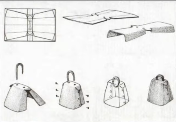
But even assuming bells were rung from the towers, how exactly was this done, and what did it sound like? Irish bells of this period were not like modern church bells. They were small, the largest being 30 cm tall, and simply made from an iron core folded over and surrounded by bronze—their sound is comparable to cow bells. They were crafted before large-scale foundries could cast bells in one piece, so they could not be used like a modern belfry with large bells mounted and swung to sound across the countryside. The large scale of the towers and the small scale of the bells is a mismatch.
The conventional explanation—that these are simply bell towers—collapses under archaeological scrutiny. No bells large enough to warrant 35-meter towers have ever been found in association with them.
When large cast bells finally arrived in Ireland in the 12th century, the towers paradoxically went out of use, something we would not expect if they had been bell-towers up to this point. The principle that function follows form suggests these massive structures, with their distinctive conical caps and cardinal-facing windows, were designed as acoustic chambers for something other than bells—specifically, for the human voice.
This article argues that Irish Round Towers were primarily vocal amplification chambers designed for liturgical chanting, demonstrating direct architectural and functional parallels with Islamic minarets. Understanding this connection requires examining not only the towers’ architecture as sound chambers but their role within the sophisticated vocal liturgical practices of early Irish Christianity and their abrupt cessation following 12th-century church reforms that sought to suppress evidence of Christian-Islamic exchange.
Monastic Positioning and Orientation
The towers’ placement within monastic complexes reveals sophisticated liturgical planning. Irish monasteries typically comprised three concentric rings:
Inner ring (sanctum sanctorum): Reserved for clergy, containing the church and primary shrines
Second ring: Accessible to baptized Christians for worship
Outer ring: Open to all, including unbaptized visitors and traders
The round towers were invariably built within the inner ring but positioned to overlook the second ring—a placement that makes sense only for structures meant to project sound and visibility outward to the lay congregation. More significantly, the spatial relationship between church, tower, and altar suggests a ritual architectural sequence with Islamic parallels.
Consider the typical arrangement: the church serves as a tabernacle housing sacred relics, with its altar oriented east—a universal direction of prayer in early Christianity, paralleling Islam’s orientation toward Mecca. The tower stands west of the church, with its elevated door (typically 2-4 meters high) always facing the church’s western entrance. Between them lies an open space that may have served as a ceremonial pathway.
This configuration creates a striking parallel to Islamic mosque architecture. The elevated platform at the tower’s door height mirrors the minbar—the elevated pulpit inside mosques from which the imam delivers sermons, typically raised 3-4 meters via a ritual staircase. The tower’s summit function parallels the minaret’s role in projecting the call to prayer. Uniquely, Irish towers seem to combine both functions in a single structure—the platform level for sermon-like addresses to gathered congregations, the summit for long-distance vocal projection.
The consistent orientation—tower door to church door, church altar to east—suggests processional liturgy. A priest could move from the eastern altar through the church, emerge from the western door, cross the ceremonial space, and ascend to the tower platform via wooden stairs. This elevated position would provide both visual prominence and acoustic advantage for addressing congregations gathered in the second ring, while maintaining sight lines to the church containing the sacred relics.
Archaeological evidence supports this liturgical interpretation. Excavations have revealed worn paths between churches and towers, post-holes for substantial wooden staircases (not mere ladders), and platform structures capable of supporting multiple persons. The investment in these wooden structures—which required regular maintenance and replacement—confirms their essential liturgical rather than occasional defensive role.
The Cardinal Windows
At the summit, beneath conical stone caps, the towers typically feature four windows facing the cardinal directions, though some examples like Glendalough have eight. This arrangement differs markedly from Continental bell towers, which typically had larger, fewer openings for bell-hanging. The cardinal orientation suggests liturgical rather than purely practical function, enabling sound projection in all directions—a feature notably paralleling the muezzin’s practice of turning to the four directions during the Islamic call to prayer.
The Voice, Not the Bell: Reassessing Liturgical Function
The conventional interpretation of round towers as bell towers faces a fundamental archaeological problem: the bells don’t exist. Despite extensive excavations at tower sites, no bells have been found that would justify structures of such monumental scale. The small hand-bells discovered at Irish monastic sites—crafted from folded iron cores covered with bronze—could be rung from anywhere. They produce sounds comparable to cowbells, with a range measured in meters, not kilometers.
Clocc – The Irish Bell
From 5th century to the year 1100 Earliest are iron to 9th from 8th century bronze bells typical 20-25 cm sometimes 30 some heavy enough to require two hads or were suspended. 60 iron 30 bronze survive |dozens referreds to in documents. Version of Roman bells from wales and the continent.
Cormac Bourke The Early Medieval Handbells of Ireland and Britain, December 2020
Bronze bells are unique to ireland -cast bronze iron bells in midlands and north.-south munster not common bronze balls almost totally ulster iron bells very much of monastic sites through the midlands. clonfad iron bells are made bell used to keep time with sundial at monastery Clocc na trath -the bell of the hours Bells become relics, Coolaun tipperary protect people in battle cures swearing gobhnait an d brigid bronze age bells are assoc with bronze bells bronze bells assoc with small churches, liturgical use in church or amongst the people at funerals saints were metalworkers who made the bells clonfad brazing shroud beeswax used for casting, lost wax moulding Names of bells – 80 – Vengeance of God for example bells sold during famine after centuries. even a failed casting would be repaired and used as once its made under invocation of the saint theres no going back!
33 cm is largest bell adomanan revenge bell, sanctiuonsing of people. black vengeful one – assoc with Skreen
Early Bell Usage in Coptic Monasticism (4th-6th Centuries)
The earliest documented use of church bells in the Eastern Christian world appears in Coptic Egypt, with evidence suggesting bell usage as early as the 4th century. A fresco of Patriarch Demianous dating to the 8th century at El-Sourian Monastery in Wadi Natrun depicts tower-like structures with ladders providing access to upper levels, indicating established tower-based acoustic signaling by this period.
The official sanctioning of church bells by Pope Sabinian in AD 604 formalized practices that had already been developing in monastic communities for centuries. These early tintinnabula were forged metal instruments of modest dimensions, preceding the larger cast bells that emerged in the 7th-8th centuries.
Before the widespread adoption of bells, Eastern monasteries utilized the semantron—a percussion instrument consisting of wooden planks struck with mallets. This practice began in 6th-century monasteries of Palestine and Egypt, including Saint Catherine’s in Sinai, where the semantron replaced trumpets as the primary means of monastic convocation.
The semantron system was hierarchical: smaller instruments were sounded first, followed by larger ones, then iron versions. Byzantine sources indicate that monasteries used three semantra while parish churches employed only one large instrument.
Ethiopian Orthodox Bell Traditions
The Nine Saints, arriving in Axum around 480 AD, were instrumental in establishing monastic practices that included musical innovations. Yared the Deacon, associated with this group, composed music in three modes still used in Ethiopian Orthodox liturgy.
thiopian church architecture from the Aksumite period (4th-6th centuries) shows Syrian influences through the Nine Saints’ work. Structures like Debre Damo represent the oldest surviving Christian architecture in Ethiopia,
Oriental Orthodox Christians, including Coptic and Ethiopian churches, continue to use canonical hour prayers marked by bell tolling, particularly in monastic settings where bells signal the seven daily prayer times.
Irish-Eastern Christian Connections
Documentary Evidence
Multiple sources document connections between Irish and Egyptian monasticism. The 8th-century Faddan More Psalter, discovered in County Tipperary, contains papyrus lining most likely from Egypt, written in oak-gall ink identical to that used in the 4th-century Codex Sinaiticus found at Saint Catherine’s monastery.
The 9th-century Martyrology of Oengus the Culdee specifically mentions “Seven monks of Egypt in Disert Uilaig,” while the 7th-century Antiphonary of Bangor refers to “the true vine transplanted from Egypt.”
Liturgical Parallels
Specific Egyptian elements in Irish Christian art include: handbell usage by mendicant monks (mirroring Coptic episcopal practice), the prevalence of Egyptian monastic pioneers St. Anthony and Paul of Thebes on Irish high crosses, and flabella (processional fans) depicted in the Book of Kells—an exclusively Eastern Mediterranean liturgical implement.
Ireland contains at least 76 places named “An Díseart” (The Hermitage), directly referencing Egyptian desert monasticism despite Ireland’s temperate climate. The Stowe Missal explicitly prays for protection “from the dangers of the desert” and seeks grace “following the example of Anthony of Egypt.”
In Coptic Orthodox liturgical practice, an exclusively vocal tradition, Coptic music is only accompanied by two percussion instruments today—the muthallath (triangle) and the sanj or sajjāt (cymbals). When played together, they not only keep time, but they also produce an intricate rhythm that mimics the embellished vocal lines they accompany.
Ethiopian Orthodox tradition maintains similar practices: common musical instruments include tsenatsil (sistrum), kebero (hand drum) and hand bell. Saint Yared sang in front of Emperor Gebre Meskel accompanied by drums, sistra, and male priests. These hymns are accompanied by various musical instruments giving the performance more fullness.
Crucially, these instruments serve liturgical accompaniment rather than independent signaling functions. They are not used as musical instruments/accompaniments, but as markers of where one is in the Liturgy and to help the Chanters keep proper pace.
Irish Continuation of Eastern Vocal-Instrumental Tradition
This Eastern pattern of vocal liturgy with instrumental accompaniment would have been transmitted to Ireland through documented Irish-Egyptian monastic connections. The acoustic architecture of Round Towers optimized both human voice projection and the resonance of accompanying handheld instruments—bells, cymbals, or small drums—creating a unified liturgical acoustic system.
Rather than simple “bell ringing,” Irish Round Towers likely facilitated accompanied liturgical chanting:
Primary voice projection from designated chanters
Rhythmic bell accompaniment providing liturgical timing
Seasonal liturgical variations requiring different acoustic patterns
Directional projection through cardinal-point windows for community coordination
The legal texts defining monastic “faithche” boundaries as extending only as far as bells could be heard makes sense in this context—the limitation refers to the range of accompanied chanting, not independent bell signals.
The Norman Crusade: Suppression of “Islamic” Liturgical Practices
The crux of the matter here is , if the towers were belfries, then the introduction of better and more effective bells should have enhanced the effectiveness of the towers. You would think, if it had been a smooth transition from a certain type of bell, to larger and louder bells, that this would be embraced. Mayber the towers would require some modification, but in general, why would they suddenly just not be built anymore. Between the first Norman invasions in 1169 and around 1200 CE, round tower building ceased in Ireland.
The archaeological record supports systematic suppression rather than gradual obsolescence. Round Towers were not abandoned due to technological advancement—they were actively suppressed as part of religious standardisation. The fact that superior bell technology should have enhanced rather than eliminated Round Tower construction suggests that their primary function was something the new religious establishment could not tolerate.
The towers represented liturgical practices that had evolved through Eastern Christian connections—precisely the kind of “Eastern corruption” that reformist movements from Gregory VII onwards sought to eliminate. Their acoustic function, involving human voice projection for call-to-prayer practices, was too reminiscent of Islamic traditions to survive in post-Crusade Christianity.
The Anglo-Norman invasion was explicitly framed as a religious mission, sanctioned by Pope Adrian IV’s bull Laudabiliter (1155), which authorized Henry II to invade Ireland “for the correction of morals and the introduction of virtues, for the advancement of the Christian religion”. John of Salisbury, Secretary to the Archbishop of Canterbury, made an “extraordinary intervention” at the Roman Curia, calling for Norman involvement in Ireland to reform its “barbaric and impious” people. This papal authorisation positioned the Irish invasion within the broader Crusading movement, framing the conquest of Ireland as liberation from heterodox practices that had supposedly contaminated authentic Christianity.
The language of Laudabiliter mirrors contemporary crusading bulls. Adrian addressed Henry as endeavoring “to enlarge the bounds of the church, to declare the truth of the Christian faith to ignorant and barbarous nations, and to extirpate the plants of evil from the field of the Lord”—rhetoric identical to that used for Eastern Crusades against Islamic territories.
The Acoustic Parallel: Round Towers and Minarets
The timing of Round Tower construction cessation (1169-1200) coincides precisely with the height of Crusading activity in the Eastern Mediterranean, where Norman knights encountered Islamic minarets daily. The functional and architectural parallels between Irish Round Towers and Islamic acoustic signaling would have been immediately apparent to returning Crusaders:
Elevated acoustic projection from tall, slender towers
Regular call patterns marking prayer times
Directional windows facing cardinal points
Integration with religious complexes but physical separation from main worship buildings
Voice amplification for liturgical purposes
Recent manuscript discoveries, including 15th-century Irish translations of Ibn Sina’s medical works and the 9th-century Ballycottin Cross with its Arabic Kufic inscription, demonstrate extensive Islamic intellectual influence in medieval Ireland—precisely the kind of “corruption” that Laudabiliter was designed to eliminate.
The synod sought to bring Irish church practices into line with those of England, and new monastic communities and military orders (such as the Templars) were introduced into Ireland. This represented systematic replacement of indigenous Irish liturgical practices with Continental standardization.
The Gregorian Reform movement, which Adrian IV championed, specifically targeted Eastern Christian influences as dangerous deviations from Roman orthodoxy. Round Towers, representing liturgical practices derived from Coptic and Ethiopian traditions, embodied precisely the kind of “Eastern corruption” that reform movements sought to eliminate.
Adrian’s justification was that, since the Donation of Constantine, countries within Christendom were the Pope’s to distribute as he would. This papal supremacy doctrine provided theological framework for suppressing liturgical practices deemed incompatible with Roman authority.
Liturgical Function and the Evidence of the Lectors
How then were these bells and towers actually used? Early Christian worship involved the chanting of psalms in responsorial form, in which a leader known as a lector chanted the psalm and the congregation responded by singing the response. This form was often accompanied by the rhythmic ringing of bells or cymbals, which are still used in Coptic and Ethiopian traditions today. It is possible that this is how Irish bells were used, as it is a task they are far better suited for than the swinging of heavy bells.
But is there any evidence for this liturgical use? Crucially, the annals refer to at least two instances in which fires in towers resulted in the death of a lector—the “fer leginn,” literally “man of reading.” This would mean the lectors were often in the towers, and in a vulnerable enough place within them not to be able to escape quickly—most likely at the top.
The towers are positioned ideally to deliver psalms to the second ring of the monastery, the place reserved for baptised Christians, while only the monks and priests could enter the inner ring. Here, the congregation in the open air could hear the psalm leads being delivered and respond accordingly.
A modern form of call-and-response Gaelic psalm singing is preserved to this day on the Scottish Western Isles, demonstrating the continuity of this tradition. If this is how the towers were used, the effect on the listener would be remarkably similar to the modern call to prayer by the Muslim muezzin from the minaret of a mosque.
The towers are uniform in construction and style, with remarkably little difference between them. This is unusual in a cultural zone that was very diverse in its fiercely autonmous political and rival territories. This strongly suggests a functional form and tends to rule out display or ritual rivalry as the reason for the towers.
The Dual Liturgical Function: Platform Display and Acoustic Amplification
Recent archaeological evidence may strengthen this liturgical interpretation. Excavations in the 1990s revealed postholes near round tower doors, confirming that wooden steps and platforms were built to reach the elevated entrances. These were not simple ladders but substantial wooden structures that created an elevated platform at the door height.
The circular nature of Irish monasteries suggests a liturgical arrangement that involved circum-ambulation—the rightward procession around sacred shrines that was important in early Irish Christian worship. The churches themselves served as tabernacles, housing shrines accessible only to priests and monks, while lay people gathered in the second ring. Like the arrangement at Mecca or Ethiopian Orthodox churches, large numbers of pilgrims could process around the sacred center.
This arrangement may hint at at least a dual function. The elevated platform at door height could have served multiple purposes: providing visibility for the priest to the circumambulating crowds, enabling the display of holy relics stored within the tower, and creating an elevated position from which to lead responsive worship.
Picture a lector on the platform chanting a psalm line that the processing congregation in the second ring could clearly hear and respond to with overlapping responses. The priest would face the church door—toward the tabernacle containing the shrines—making the tower platform a natural extension of the sacred space.
Meanwhile, the conical summit with its four cardinal windows served as an acoustic amplifier. Whether the lector sang from the platform or climbed to the top for maximum projection, the four windows facing the cardinal directions would carry the chant across the entire monastic complex. The impressive height of these towers—up to 130 feet—may reflect both the size of pilgrimage crowds they needed to serve and the distances across which the liturgical bells and chants needed to carry.
This dual function mirrors liturgical arrangements found in other traditions where elevation serves both visual display and acoustic projection, but the specific combination of platform accessibility and summit amplification appears to be uniquely Irish—or perhaps uniquely adapted from models encountered in the sophisticated religious architecture of Islamic Spain.
Sound Propagation Modeling
Modern acoustic analysis provides quantitative support for the liturgical function of Round Towers as proposed in the main text. The towers’ design features—elevated platforms at door height, substantial height (65-130 feet), and four cardinal windows at the summit—create an optimal configuration for both local responsorial worship and wide-area acoustic projection.
Chamber Acoustics at Tower Summit
The uppermost chamber of a typical Irish Round Tower presents a compact but highly effective acoustic environment. Under the corbelled stone dome, this chamber measures approximately:
5 m diameter
2 m height (from wooden floor to dome apex)
Volume ≈ 39 m³ (approximated as domed cylinder)
Four small cardinal openings totaling ~0.56 m² aperture area
Reverberation Characteristics: Using standard acoustic modeling with absorption coefficients for:
Stone walls/dome: α = 0.02 (highly reflective)
Wooden floor: α = 0.1 (moderate absorption)
Window openings: α = 1.0 (total absorption)
The total absorption area (A) equals approximately 2.96 sabins, yielding:
This moderate reverberation time, particularly effective in the 300-600 Hz range optimal for human chest voice, would significantly enhance liturgical chanting by adding richness and sustain to the vocal line.
Sound Pressure Level (SPL) Enhancement: The compact, highly reflective chamber creates substantial sound pressure buildup. A lector chanting at typical vocal levels (~90 dB SPL at 1 meter in open air) would experience:
+6-10 dB enhancement within the chamber due to reflective reinforcement
Focused projection through the four cardinal apertures
Estimated external SPL: 80-85 dB at 1 meter from openings (accounting for ~15 dB aperture losses)
Comparative Sound Decay Analysis
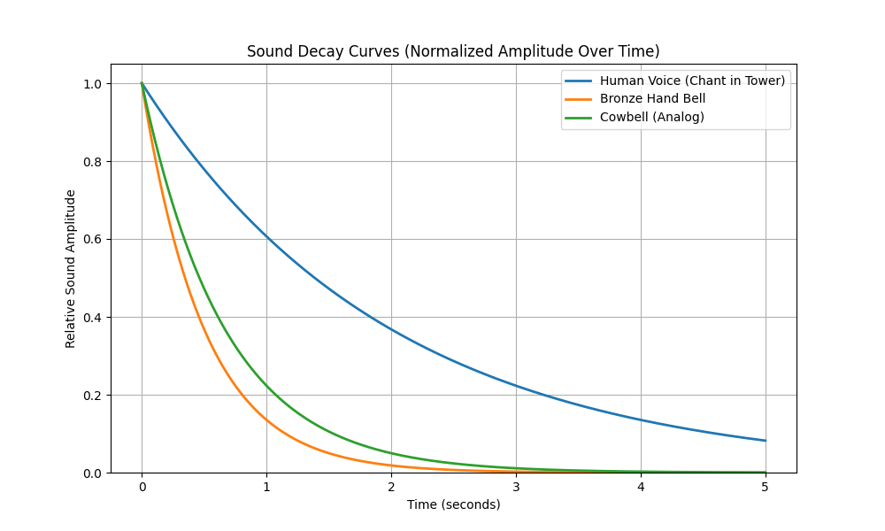
Quantitative analysis of sound decay characteristics reveals the acoustic priorities embedded in Round Tower design. Using exponential decay modeling for different sound sources:
This analysis demonstrates that the human voice in the tower chamber maintains sustained amplitude for several seconds (k = 0.5), while early medieval Irish handbells exhibit rapid decay (k = 2.0). The chamber’s 2.1-second reverberation time specifically enhances the vocal sustain, creating optimal conditions for responsorial chanting where the congregation needs time to hear, process, and respond to the psalm leader’s call.
Source
SPL @ 1m
Duration
Directionality
Human voice (Adhan)
~90 dB
Sustained
Directional
Irish handbell
~70-80 dB
Brief peak
Omnidirectional
Cowbell analog
~75 dB
Medium decay
Omnidirectional
Spatial Analysis and Acoustic Coverage
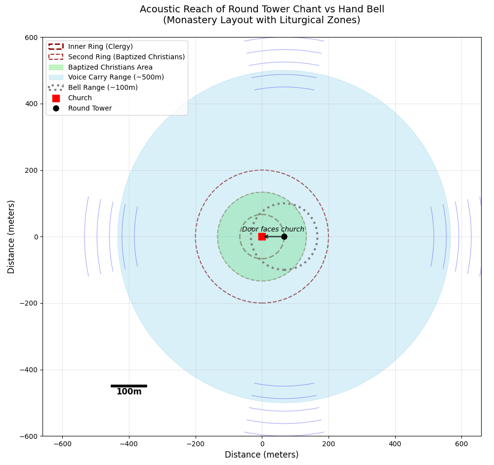
The following spatial analysis demonstrates the acoustic superiority of vocal projection from Round Towers compared to handheld bells, supporting the liturgical interpretation of tower function:
This spatial analysis reveals several key insights:
Voice projection covers the entire monastery complex and extends well beyond, reaching 5x the distance of handheld bells
Strategic positioning at the inner ring edge provides optimal acoustic coverage of the baptized Christians’ area
Cardinal window orientation creates enhanced directional projection for maximum liturgical effectiveness
Door orientation toward the church confirms the liturgical relationship between tower and altar
The acoustic coverage pattern strongly supports the interpretation of Round Towers as platforms for vocal liturgical leadership, functionally parallel to Islamic minarets serving the muezzin’s call to prayer.
Connections to Islam
Kairouan mosque dating to 724-727 AD (not 836 AD) per recent scholarship
Add evidence of sustained intellectual exchange beyond just book sourcing Reference the sophistication of both Irish and Islamic Spain as “the only fully literate civilizations in western Europe” Include evidence of medical manuscript translations showing ongoing scholarly contact
The construction of Irish round towers coincides with the development of the minarets in the western Islamic world. The earliest known example is at the mosque at Karouan in Tunisia and dates from 836 AD. Minarets appear to have spread from west to east after this time. They were also built in Spain over the next few centuries as it was under Muslim control at this time. The development of Irish round towers and minarets is contemporary,and importantly, painstaking attempts to link the Irish towers to Roman and Continental bell towers have failed to find convincing parallels.
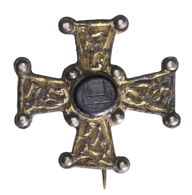
Contact between Islamic Spain and Ireland is undoubted at this time as these were the only sophisticated literary cultures in western Europe during these centuries. Books were sourced here by Irish scholars eager for knowledge, and many Greek and Latin and Hebrew texts were translated in Umayyad Spain. Arab Christian contact is shown by artefacts like the 9th century Ballycotton cross from Co. Cork, on which is the inscription “In the Name of Allah” in Arabic Kufic script. There are similarities between Irish and Islamic law courts which may show influence.
Ballycotton Cross, It is a 9th-century jewelled Celtic/Carolingian cross with a centre glass jewel with an inscription of the Bismillah in Kufic script, “In the name of Allah”
Many features of early Christian worship were common to both Islam and Christianity. This is due to their common origin in Jewish, Syrian and Egyptian forms of worship. For example, the chant or singing had a common origin in Jewish temple singing, the use of prayer mats, which were used in Ireland also, and the full prostration to the floor, still practised by Coptic Christians to this day.
Four cardinal windows and liturgical turning practices Elevation providing acoustic advantages for chanting Comparison with minaret balconies for prayer calls Evidence from contemporary Christian practices in Middle East
On an Islamic minaret, the muezzin delivers the adhan, he turns to the four cardinal directions. This was a feature of early Christian prayer as well, and as we have noted, the windows on the upper storey of the round towers usually face the four points of the compass, perhaps to allow this turning clockwise that was feature of early Irish prayer.
When Irish Christianity and Islamic Spain stood for centuries as the only fully literate civilisations in western Europe, both being harassed by pagan Vikings and Germanic tribes from the east, is it far fetched to imagine they may have seen more commonalities than differences? In an age before the religious crusades this ids quite plausible.
Archaeological Evidence for Contact
Detailed analysis of Ballycottin Cross findings Discussion of other Irish-Islamic artifacts or influences Evidence from medieval manuscripts showing Arabic medical knowledge in Ireland
Demise of the Towers
Roman Catholic contact with the Islamic world from the 11th century on through the crusades, created a concern to differentiate themselves from any vestiges of common heritage that may have existed between the religions. One can well imagine that it maybe the case that the Irish round towers were too reminiscent of exactly this heritage, and after the Roman sponsored Irish church reforms in the 12th century, and particularly the Norman invasion, (which the church backed) no tower was ever built in Ireland again.
In fact, it is not a stretch to imagine that the Norman invasion was really a Crusade against the Irish form of Christianity, one that, thanks to its antiquity and despite the fact that it had preserved and spread Latin civilisation after the collapse of the of the Roman Empire, gave the game away as to the common origins of the two great religions of the western world.
Notes:
“The 10th year, a just decree, joy and sorrow reigned, Colman Cluana, the joy of every tower died; Albdann went beyond the Sea.”
( AFM pub. Dublin 1856, vol II pp. 612 3)
But in at least two cases the monastic fer leginn, ‘lector’ or master of learning, was the victim: at Slane in 950 (the earliest reference to a round tower in the annals) the fire consumed a crozier, a bell, Caenechair the lector, and a multitude with him
(A. U., A.F.M., C.S., A. Clon.), and the lector was burned in the tower at Fertagh in 1156 (A.F.M.; A. Tig. has Aghmacart).
Here Ann Hamlin notes the association of lectors with the towers, but then fails to follow the logic that they were more than likely doing their normal job. The simplest explanation is the first that should be tested of course.
“The great majority of annal references to the fer leginn are simply obits, and it is interesting to note this association with round towers. Could this be a hint of a special role for the lector, to organise the retreat to the tower with books, relics, service equipment and treasures, and perhaps other refugees, to sit out the attack? “
ANN HAMLIN Historic Monuments and Buildings Branch, Department of the Environment (N.L)
Address the mobility-based Irish defense concepts (your point about Irish military strategy) Distinguish between secure storage during use vs. permanent storage Add evidence of lectors being present during tower fires Expand on responsorial chanting practices with Coptic/Ethiopian parallels
Linguistic and Semantic Parallels
Address the “cloigtheach” vs. “cloch” semantic complexity Compare with “manāra” meaning lighthouse/beacon rather than prayer call Discuss how both terms evolved in meaning over time Note that functional names can shift while architectural forms persist
Recent Scholarship and Reassessment
Discussion of how previous “mystery” around towers may reflect later discomfort with Islamic connections Address why bell tower function and Islamic influence aren’t mutually exclusive Review how recent archaeological and manuscript discoveries support the thesis
Conclusion Further Directions
Synthesise the contemporary development, contact evidence, and functional parallels Address why the thesis remains valid despite acceptance of bell usage Suggest areas for future archaeological and historical research
Bibliography
Primary Sources
Annála Ríoghachta Éireann (Annals of the Four Masters). Ed. John O’Donovan. Dublin, 1856.
Annals of Ulster. Ed. Seán Mac Airt and Gearóid Mac Niocaill. Dublin Institute for Advanced Studies, 1983.
Indiana: Balloq’s medallion only had writing on one side? You sure about that?
Sallah: Positive!
Indiana: Balloq’s staff is too long.
Indiana: Sallah: They’re digging in the wrong place!
Raiders of the Lost Ark, (1981)
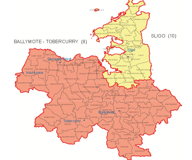
County Sligo, and the old Borough Corporation of Sligo town are roughly 400 years old, and both are creations of the British Empire and its nascent colonial enterprise in Ireland. As part of the Imperial project of extending centralised control across the country from Dublin, the counties were created as brand new entities on top of the earlier Irish Gaelic political territories. These older territories were called tuatha (countries). The tuatha that made up what is now County Sligo are shown on the map accompanying this article.
County Sligo was created by joining together the Gaelic tuatha of what was then known as Iochtar Connacht (Lower Connacht). This was made of five ancient tuatha. Each one had its own lord and public assembly. Each had a small army and system of law courts under the Irish law known as Fenechus (Brehon law). These tuatha in turn were arranged in a hierarchy, with the chief one in this area being Cairbre Drom Cliabh. So the local overlord at the time of the conquest was the chief of the O ‘ Conchobhar Sligigh (O’Conor Sligo), a family related to the O ‘ Conor kings of Connacht. The chiefs of the other tuatha were Ua hEaghra of Luighne, Mac Donnchadha of Tir Olliol and Corann and Ua Dubhda of Tir Fhiacrach. Each of these territories was renamed as well, they were called baronies and became electoral divisions under the British administration. Luighne became Leyney, Tir Olliol became Tirerrill, Tir Fhiacrach became Tireragh and so on.
Sligo Borough Council had been set up in 1613 as part of the reorganisation of territories under the English conquest. It extended in a circle one mile from the Market Cross. Some of the boundary markers still exist along the sides of the road. The county was an earlier creation, around 1585, of Sir Henry Sidneys “shiring” program under the Surrender and Regrant scheme intended to Anglicise the country.
The new county and borough structure obviously facilitated British rule from Dublin and the collection of taxes for the new administrators. But, the newly named counties served one other very important purpose. Simply by creating an entity with a new name, they disconnected the people from the earlier history of the country. Because the counties remained in operation after independence, this effect is still in operation today.
Under the new reality, the old chief families in every branch of Gaelic society were marginilised. Their history went back in many cases as long as the tuatha themselves which is about 1, 600 years, far longer than the counties that came after them. However their pedigrees and claims, no matter how ancient, were now worthless because they referred to territories that no longer officially existed. And so by a trick of the pen and the mapmakers artifice, Irish people became strangers in their own land.
As knowledge of the old territories faded with the loss of the Irish language in the area, so did the knowledge of how the land had been organised and connected to its Gaelic past. The placenames are the key to that connection, and without them we are blocked from understanding the ancient history of our area. For example, Cairbre is named after Cairbre Mac Neill, son of Niall of the Nine Hostages, and Tir Fhiacrach from Fiacra a half brother of the same ruler and one of the three Connachta from which most of the ruling tribes of Connacht traced their descent. That it was from this part of Connacht that the Ui Neill and Connachta dynasties expanded across the northern half of Ireland. is actually witnessed by the names of the territories. And others open connection to other histories and mythology, such as Corann, which is named after the harper of the Tuath De Danaan, who was granted the land after the second battle of Moytura. There are endless connections of this sort. You get the picture.
However, it is not only written history and mythology we are disconnected from. The physical remains around us are also cut off from the context in which they were created. This means they become mysterious and are subject to archaeological investigation as if they were prehistoric, even though we have extensive records available about their histories. This is a bizarre effect of using the wrong political boundaries to explain Irish history. To put it simply, we are using the wrong maps. To explain history, we need to understand the context of events, and the tuatha provide the context of most of Irish history. Therefore historical tourism is also suffering from this problem, as lack of information and awareness of the reality of Gaelic Ireland causes endless confusion as to how to interpret our past. We must be aware that every historic castle, church, monastery, ringfort. holywell and numerous other historic sites existed and were created within the tuath system, and therefore their placement and use is only understandable in relation to this political reality.
The ancient tuatha from which County Sligo was made. They lasted officially until the 17th century. The districts are at least 1,500 years old, and probably much older.
Which brings me to the present. History goes in cycles they say. When the government abolished the borough council of Sligo town, rolling it together with the county council to create two districts in County Sligo. The northern one is now called the Sligo Borough District. The aim, at least on paper, was to create a flatter hierarchy of local government and prevent duplication of services, although the open conflict between Sligo Borough Council and the central government over the Eastern link bridge can’t have helped.
However, when the new administrative boundaries were drawn something quite remarkable happened. The new Borough District is an almost exact match for the ancient tuath of Cairbre Drom Cliabh.
Map of County Sligo showing the new Sligo Borough District in yellow. It has basically the same boundaries as the tuath of Cairbre Drom Cliabh.
This has come about because the older territories reflected geographical and social realities that have not changed over the centuries, and because of their organic development, they represent these realities more accurately and subtly than the counties, which were imposed from the top down by a centralised and alien administration in Dublin.
Whatever the reason for its re-emergence as a political unit, it represents an opportunity to experimentally begin to revive the connections to the history of this part of Sligo. The way forward is simple. For the purposes of historical tourism the tuath name and maps should be used in all historical literature that deals with sites that predate the 17th century. This means most of our historic sites should be interpreted in this way. Signs should also mark the boundaries of these historic tuatha, and inform people when they are entering and leaving them. Of course, post 17th century historic sites, like big houses etc, should rightfully be set in their particular context, which is the English County system as we know it now.
By stripping away the colonial era layer, thousands of years of history, myth and culture will be accessible in a way that has so far eluded us, and the re-appearance of an ancient Irish tuatha, albeit accidently, shows that there are practical reasons why this would be beneficial, not only in Sligo, but across the whole country.
In 2005 excavations took place on the site of the present Glasshouse hotel. The site had been that of the Sligo Mills, owned by the Pollexfen family in the late 19th and early 20th century. The Pollexfens were WB Yeats maternal family.
Mills on the site appear to have been there at least since the 16th century, but probably much earlier and there may have been even earlier mills associated with the castle since the 13th century.
The milling interests owned by the Pollexfen family became a limited company in 1913 and was thereafter known as Messrs. W. & G. T. Pollexfen and Co. Ltd. The Sligo mills were located at Victoria (Hyde) Bridge and by 1926 the production output was one hundred tons of maize per day. In 1927 the Sligo Mills were closed.
The mills were an important part of the industrial history of the town, and were employers of large numbers of people. Carters, millers and numerous dock workers were involved in the business. Maize was imported to be ground here.
The mills played a colourful part in the history of the town, not always without controversy, becoming involved in the 1913 Sligo dock strike. During the strike, a particularly violent strike which involved much rioting in the town, Patrick Dunbar, a striker, of Riverside, who was employed at Pollexfen’s Mills and was a married labourer and member of the I.T.G.W.U. was assaulted and later died from his wounds during fighting between the strikers and labourers shipped in to break the strike. This led to reprisal attacks on Pollexfen’s clerical workers, when strikers broke the windows of their offices. Hundreds of police and soldiers were brought in to the town to protect property.
The mill was converted into a cold-storage facility in the 1930s.
The Mills
The mills were tidal mills, with the water at high tide supplementing the flow of the river to fill the millpond and drive the huge wheels used to power the mills. This means the mills stopped twice a day at high tide when the flow of the river effectively stopped. The millpond was upstream, and formed by the weir which extends across the river just upstream from Hyde bridge. A large part of the weir was broken down in the 1960s during the construction of the Silver Swan hotel on the site, the rubble forms the “rapids” near the bridge. This was to stop it from pushing the flow of water under the building as it was designed to do. The weir was supposed to be rebuilt, but that has not happened yet.
Archaeology
The mill was powered by three large undershot waterwheels, one external mounted to the side of the building, near where the modern side entrance to the hotel is. Two internal wheels of c. 3.8m in diameter were fed by two brick arched headraces. Two arched tailraces exited between Fish Quay and Martin’s Quay to the north. The internal race had been extended in the later 19th century to reclaim ground for the construction of ancillary mill buildings. The millraces were filled in with rubble in the 1960s during construction of the Silver Swan but survived largely intact at the time of the excavation.
The most remarkable finds were of at least seven millstones in various states, some of which are pictured here. These millstones are 4 and a half feet in width. These type of composite millstones are not very common, as they tend to fall apart and are lost once their iron binding hoop disintegrates. They were of a French type, and most likely imported from there. their composite nature allowed them to be more easily transported and assembled on site. One was in excellent condition, still bound by its iron retaining hoop. They are an important reminder of Sligos industrial heritage, but the lack of a regional museum means they cannot be displayed.
Other features found included large curved wooden sluice gates that survived in situ. These were slatted timber and at least ten feet in height and were painted with red lead that had preserved them.
Also surviving were three axle-bearing blocks with associated pit-wheel pits and a lay shaft pit (see photos), all built in ashlar (cut stone) masonry. Finds from the backfill of the pit-wheel pits were fragments of a metal axle collar. The axle blocks still contained grease from their last use.
Grooves cut into the stone by the wheels when they went off centre were visible scored into the masonry, showing the power of the wheels when in motion.
To the north of the mill building and also surviving were the near-complete structures of Fish Quay and Martin’s Quay. These stone masonry quays were built in irregular courses of squared roughly faced blocks and survived on site to a depth of 3.1m. The quays were linked by a triple-arched bridge, built off the bedrock, with two stone ashlar piers and three red and yellow brickwork segmental arches. The bridge may have been a later 19th-century rebuild of the original wooden bridge. The bridge, and sections of quay, although in good condition were demolished to make way for the underground carpark..
1875 map showing the intact weir that guided water under the mill buildings, the tailrace flow exited on the other side between Fish Quay and Martins Quay. The small cutstone bridge that was found is visible also between the two quays.
Two large metal casings for Leffel turbines were installed at the south-east corner of the mill as a source of power. The turbines had been removed, but remaining were the circular horizontal turbine housings, 1.54m in diameter, bolted into a wooden floor in the submerged turbine room.
At the very lowest levels, above the bedrock, remains of possible wattle structures were encountered. these were in poor condition and could not be investigated due to time constraints.
Postscript: All features surviving on the site were destroyed during the construction of the Glasshouse hotel complex. This shows the problem with granting permission for underground works prior to investigation of a site.
An attempt to retain the millstones for Sligos heritage was made, but the stones could not be transported to the current museum site because of limited access for machinery. They were subsequently supposed to be incorporated into the development, but with the financial collapse they were abandoned for a time. The lack of a museum in Sligo means they could not be retained and are currently believed to be in private hands.
In 2007, during routine extension works, archaeologists struck a stone covering an old drain right under the present Weekender office on Teeling street. When the stone was lifted an unusual type of wine bottle was found, known from its shape as an onion bottle. These onion bottles were made between 1640 and about 1720 and are very rarely found intact. So it was decided to extend the excavation to see what else might be there. The bottle turned out to be sitting beside a massive mortared stone foundation 3 metres (10 feet) in width which is shown in this picture.
Many of the buildings on the corner of Abbey St. and Teeling St. appear to use this as their foundation as it runs east and north directly under the modern buildings. At bottom right of the picture the modern wall can be seen to be sitting on similar masonry.
The Castle
The enormous width of the foundation suggests a fortified building, probably of a type known as a tower house. These tower houses were extremely common in Ireland all through the Middle Ages, it being a rather unstable place for anyone who had anything to protect. Lynchs castle on Shop street in Galway, now an AIB bank, is a good example of an urban tower house familiar to many Sligo people.
Some tower houses had projecting corners, called flankers, to allow defenders to fire along the wall faces, and this may be what we are looking at in this picture. This is the only definite evidence of a castle so far found in Sligo.
Who built this castle?
In the 19th century Woodmartin described a castle set back from the corner of Abbey and Teeling streets, and mentions it had been found earlier in the century during the digging of a drain, just like this one. He believed it belonged to the O’ Creans. More recently, historians have identified it as Jones castle.
But the truth is we cannot be sure. as there was in fact more than one castle in this area. An eyewitness description of the fighting in Sligo in the 1640’s mentions that“the enemy possessed of the Lady Jones her Castle, which was nigh adjoyneing to Andrew O’Crean his Castle”. Clearly, there were at least two castles right beside each other, and so without further investigation we cannot be sure which one we have found.
There are two possibilities. This castle was built either by the O’ Creans or Jones, families with very different origins, both of whom played a prominent part in the history of Sligo.
The O’ Creans
The O’ Creans (O’ Croidhen, Cryan) were an old Gaelic family from Donegal who were both merchants and religious in occupation. They were the most important medieval merchant family of Sligo, mentioned twice as wealthy merchants by the Four Masters in 1506 and in 1572.
The Jones
Lady Jones was the wife of Roger Jones, an Elizabethan soldier who served during the Nine Years War. He arrived in Sligo after the war in 1602, when a new English administration was being set up in Sligo.
Connections
Now, when Jones arrived in 1602 the town lay in ruins and so he appears initially to have used Holy Cross as a court-house. Soon after and nearby, he built his castle and Jones became constable of the new jail and also served as the first high sheriff and justice of the peace of the county. He had a garrison under his control and was responsible for the imposition of English law and order.
And so the castle he operated from on Teeling street is the direct ancestor of the modern Garda barracks, the solicitors offices and courthouse all of which, in both function and location, are descended from Roger Jones early English administration in the county. The post of high sheriff was only abolished in 1922
Meanwhile, in the Abbey the elderly Dominican friar Macduane was quite alone in Sligo as his life drew to a close in 1608. To those about him he confidently foretold that another Dominican would come to Sligo in time to give him the last sacraments. And sure enough, Daniel O’Crean, a young man fresh from his studies in Lisbon, arrived to comfort the old priest in his final moments.
An Irish college had been founded in 1593 in Lisbon. The O’ Creans as merchants were heavily involved in the wine trade and through their connections with Galway they traded directly with France, Spain and Portugal, England and Flanders, importing wine, iron and salt, and spices such as saffron, in exchange for fish, hides and cloth. Sligo was not as remote as we sometimes think.
Now, in an unusual twist, the two families became connected in the 1620’s with the marriage of the merchant Roebuck Crean and Jones niece Elicia and so they went into business together with Roger running a shop beside his house.
The bottle probably arrived the same way as Daniel O’ Crean, through the port.These bottles normally contained wine, but were often used as decanters on tavern counters long after the original contents had been drunk. There is mention of the lower floor of Jones castles being used as a tavern sometime around 1700. Perhaps the Town & County club continues this tradition today.
The castle appears to have been pulled down shortly after the 1798 rebellion. After it had been demolished, someone had carefully placed the bottle under the stone but of course why, when and by whom is unknown. But no doubt the person who placed the bottle was aware of the history and left it to point us in the right direction.
Postscript: The foundation has been reburied as there was no attempt to allow for it to be displayed. The current whereabouts of the onion bottle are unknown. Without a local museum, it could not be retained in Sligo.
An updated version of an article that first appeared in Sligo Weekender in September 2014.
The images above are of multiple new paths developing on the north side of the cairn which was traditionally pristine and unused for ascending or descending when the old path up from the south was still in use.It is particularly vulnerable to slippage as it was never bedded in by use.
Back in 2007, it was suggested in a local newspaper article that the cairn on Knocknarea was suffering wear and tear due to people climbing up it as they had done for centuries.The well worn path that people had traditionally used is on the south side of the cairn, here the stones are well bedded in and are not prone to fall. The groove that this path forms up the face of the cairn was mistaken for recent damage by the writer. This led to the erection of a sign forbidding people to climb the cairn. But the cairn had in fact not altered in centuries.
In the 1990s the cairn was surveyed by archaeologist Stefan Bergh of NUIGalway and the measurements were compared to earlier ones by antiquaries more than 2 centuries ago, he concluded the cairn was the same size and shape and that no substantial collapse or alteration had happened in the meantime. It is often true that well meaning attempts to make things better, often lead to results the exact opposite of those intended. Since the erection of the sign, the cairn is now being damaged at an unprecedented rate.
The fact that only on top of the cairn is a 360 degree view of the surroundings available means the temptation to ascend the cairn is strong. Now, of course, human nature being what it is, some obey the sign and some do not. But the tendency amongst those who do climb the cairn is now to go round to the north side of the cairn out of view of the sign and ascend from there. This side of the cairn was never bedded in, and consists of loose stone. As the photos show, a new path has developed where there was formerly none, and the loose stone is falling and threatening to cover the north marker stone. This is not the only new path forming, just the worst one.
To interfere with peoples ancient pattern of movement is always a dangerous idea. When all were allowed up, a kind of rough equilibrium was established between those who brought stones and those who took them away. Now,a new pile of stones almost 6 feet high is developing on top of the cairn which should be a shallow dish shape. Also the tradition of bringing a stone up the cairn is no longer functioning as these were traditionally cast on the sides, maintaining the general profile of the cairn.
I’m afraid that if this takes its usual course, damage caused by an ill advised and unnecessary interference in the first place, will lead eventually to a call for no access to the cairn at all in the future. An outcome which I think is totally unnecessary and draconian, as well as denying people the wonderful experience of the view from the top.
The solution is obvious. Access should be reinstated strictly on the traditional path, which should perhaps even be subtly reinforced. It should of course be made clear that only that path is to be used both to ascend and descend, and the rest of the cairn may then be roped off.
A monument such as this is a dynamic thing, it relies on the interaction of people to preserve it, and it is extremely ironic that it is through well intentioned efforts to “preserve” it that the cairns equilibrium is now threatened. Pressure has been mounting through increased access to the mountain and increased tourism on the Wild Atlantic Way. The future status of this monument needs to be thought about very carefully, and state instincts to block access are not necessarily in the best interests of the cairn or tourism.
The cairn survived five thousand years under the original arrangement, the people of Sligo had looked after it successfully for all that time, and if we want it to survive another five thousand I hope this is done as soon as possible.
Here is a link to a cached version of the original article in Sligo Weekender that caused the erection of signs prohibiting access for the first time in 2007. No study had taken place on whether damage was occurring, or what would be the best method to ensure the preservation of the cairn. The action was taken merely on the opinion of a single individual. Damage to Cairn
On September 4th 2014, the detrimental effect and threat of the access ban to the physical integrity of the cairn was noted in a letter to the Weekender by myself, of which the article above is an updated version. It was predicted at that time that the damage would get rapidly worse, as the dynamic equilibrium established under local tradition was upset by an ill advised intervention by the OPW, working off well intentioned, but incorrect, assumptions. Unfortunately this has turned out to be true. Compared to the ease of erecting signs prohibiting something, and the tendency to assume this is “doing something” it may seem counter-intuitive, but it is necessary to grasp that access to the cairn actually ensures its preservation as a living monument, whereas blocking this access ensures the exact opposite, its destruction and eventual sequestering as a ruined monument.