First in a three-part series introducing a groundbreaking approach to archaeological data science
The Hidden Patterns in Ancient Landscapes
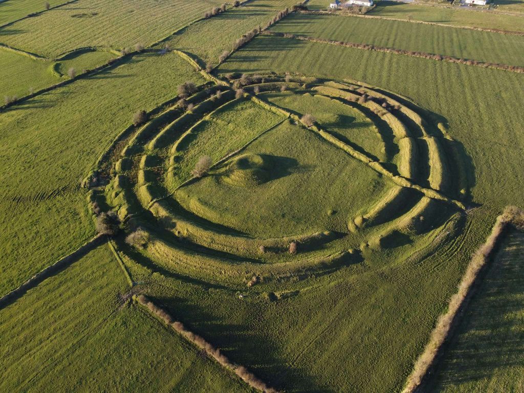
Imagine standing in a field in County Roscommon, looking at what appears to be just another Irish pasture crossed by modern fence lines. But beneath your feet and etched into the landscape around you lie the traces of something far more ancient—circular earthworks, enclosures, and pathways that once formed part of a sophisticated territorial system spanning millennia.
This is Rathra, and it perfectly illustrates both the promise and the problem of modern archaeology. We can see the ancient patterns, but they’re overlaid, interrupted, and partially obscured by thousands of years of subsequent activity. Traditional archaeological recording treats this as discrete layers—Medieval here, Bronze Age there—creating disconnected snapshots that miss the deeper story.
What if we could read these landscapes like signals?
The Typological Trap
For over 150 years, archaeology has organized its data using categories inherited from the 19th century: “Bronze Age,” “ringfort,” “barrow.” These labels seemed logical when archaeology was primarily about museum collections and cultural chronologies. But they’ve become a prison.
Consider what happens when we try to apply machine learning to archaeological data structured this way:
- Temporal relationships disappear into broad, arbitrary periods
- Uncertainty gets hidden behind confident-sounding labels
- Dynamic processes become static categories
- Observed facts get mixed with interpretative assumptions
The result? Archaeological data that’s fundamentally incompatible with modern computational analysis. We’ve been trying to do 21st-century science with 19th-century data structures.
Archaeology as Signal Science
But there’s another way to think about archaeological remains: as degraded signals from past human activity.
Every stone circle, every earthwork, every scatter of pottery represents traces of ancient “motion patterns”—the systematic ways people moved through and organized their landscapes. These signals have been subject to natural decay, vegetation growth, later human activity, and countless other forms of interference. Our job as archaeologists becomes a form of inverse signal reconstruction: working backward from degraded traces to infer the original patterns that created them.
This isn’t just a metaphor. When we apply signal processing mathematics to archaeological data, remarkable patterns emerge that traditional methods simply cannot detect.
The SETI Connection
This approach aligns archaeology with some of the most cutting-edge science happening today. SETI researchers search for “technosignatures”—traces of technological activity across vast spans of space and time. They’re essentially doing inverse signal reconstruction on cosmic scales, trying to separate intentional patterns from natural noise.
Douglas Vakoch and other SETI scientists have called for archaeological input precisely because we face similar challenges: detecting degraded signals of intelligent activity across enormous temporal distances. The mathematical frameworks are surprisingly similar.
But where SETI looks outward for signs of non-human intelligence, archaeology looks backward for signs of our own species’ complex behaviors. We’re both trying to answer the fundamental question: How do you detect intention in noisy, incomplete data?
What This Makes Possible
By treating archaeological features as signals in a unified mathematical framework, we can:
- Detect anomalies that reveal historical disruptions (like invasions) through negative correlations
- Identify persistent patterns that span millennia, invisible to period-based analysis
- Quantify uncertainty using probabilistic methods rather than hiding it behind labels
- Scale analysis to continental or global datasets using automated pattern recognition
- Integrate seamlessly with remote sensing, climate data, and astronomical datasets
A New Kind of Archaeological Science
In our upcoming research publication, we demonstrate this approach using 6,000 years of data from northwest Ireland. The results are remarkable: we can detect territorial boundaries that persist from the Neolithic through the Medieval period, identify the signatures of different political federations, and even automatically detect invasive territorial patterns like the Norman conquest—all from spatial data alone, without relying on historical records or typological classifications.
This represents the emergence of a genuinely new archaeological science: one that can operate at the scale and precision demanded by contemporary global challenges, from understanding long-term environmental adaptation to modeling resilient territorial systems.
What’s Next
In our next article, we’ll dive into the technical breakthrough that makes this possible: treating time as space within a 3D mathematical framework that transforms temporal relationships into geometric ones. This seemingly simple shift opens up entirely new ways of reasoning about archaeological data.
The third article will walk through our Ireland case study, showing how 6,000 years of human territorial behavior becomes visible when viewed through this new lens—and what it tells us about the deep continuities underlying apparent historical change.
This isn’t just a new method—it’s a new way of seeing the past.
Dylan Foley is a researcher in archaeological data science at Atlantic Technological University, working under the supervision of Dr. Eoghan Furey. Together, they are developing new approaches at the intersection of machine learning, signal processing, and landscape archaeology that bridge archaeology with SETI research, planetary science, and advanced computational methods.
Next: “Treating Time as Space: A New Framework for Archaeological Machine Learning”