How one of Ireland’s most significant Neolithic landscapes is reshaping urban planning in the 21st century
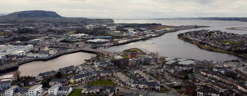
Sligo town occupies one of the most archaeologically constrained urban environments in Europe. As the town faces mounting pressure for housing and development, its unique position—literally built within and surrounded by one of the world’s most significant Neolithic ritual landscapes—presents planning challenges unlike anywhere else in Ireland.
The southern peninsula on which much of Sligo sits is not merely dotted with ancient sites—it is an archaeological landscape. The Coolera Peninsula contains 30 surviving megalithic tombs with another 25 destroyed since 1800, making Carrowmore one of the largest clusters of megalithic tombs in Ireland. But this represents only the most visible layer of an archaeological palimpsest extending across the entire peninsula.
The peninsula contains the oldest dates found around Sligo, with Swedish archaeologists recovering dates from 5,400 BC from charcoal found close to the monuments. This places continuous human activity on the peninsula for over 7,000 years—longer than anywhere else in Ireland has been continuously occupied.
The landscape operates as “a protected National Monument” where “the legal protection of a national monument extends to include the surrounding area”—a landmark 1989 legal ruling that marked “the first explicit legal recognition of the idea of an architectural landscape”.
The Imminent UNESCO Constraint
The passage tomb landscape of Co Sligo has been approved for inclusion on Ireland’s tentative list of world heritage sites, moving the county a significant step closer to UNESCO World Heritage designation. This is not a distant possibility—Ireland expects to submit its first Preliminary Assessment Request for one of the Tentative List sites to the World Heritage Centre in September 2025.
The UNESCO application covers Carrowmore and Carrowkeel, Knocknarea and Cairns Hill, the Ox Mountains and part of the Ballygawley hills, plus an area around Keash. Crucially, this includes areas immediately adjacent to Sligo town center, effectively creating a planning boundary that cannot expand westward or southward.
Current Archaeological Stress
The archaeological landscape is already under severe pressure. Five-thousand-year-old Neolithic tombs in Co Sligo are suffering damage and vandalism “on a scale never seen before”. The problem extends beyond tourism damage—it reflects the fundamental tension between a growing modern town and an intact Neolithic landscape.
Without a robust plan, Carrowmore Megalithic Cemetery would now be adjacent to the town dump; in the nineteen eighties the council had a pressing need for landfill and only the determined efforts of local residents and legislators in the Supreme Court upheld the 1980’s Development Plan. This near-miss demonstrates how development pressure can threaten even the most significant archaeological sites.
The Physical Geography Trap
Sligo’s constraints extend beyond archaeology. The town is positioned between Lough Gill to the east and Sligo Bay to the north and west. The southern peninsula—the only significant direction for expansion—is precisely where the densest concentration of archaeological sites exists.
Knocknarea’s summit and slopes hold 10 Neolithic passage tombs, hut sites, boulder circles, banks and ditches, a quarry where stone tools were made and the remains of a deserted pre-famine hamlet. Archaeological remains on the mountain belonging to the Neolithic period consist mainly of a series of passage tombs, round house foundations as well as a complex series of banks along the upper eastern slopes.
This creates an unprecedented planning situation: a modern town hemmed in by water on three sides and by one of Europe’s most significant archaeological landscapes on the fourth.
The Development Planning Crisis
The archaeological constraints are already causing political friction. Councillors are being asked to reverse a decision they made 14 years ago on the eve of an important World Heritage Site announcement regarding development proposals near Cairns Hill, which contains two unopened passage tombs, a key element in the World Heritage bid.
The tension between housing need and heritage protection is acute. This is not for a moment to diminish the plight of those who are so in need in the housing market. We do need to address these issues. But I would still advocate balance, and a reasonable degree of caution.
Current planning policy acknowledges the constraints: Sligo has the largest group of archaeological sites/remains in the country and the protection of these sites is of paramount importance to Sligo County Council.
The Unique Challenge
What makes Sligo’s situation unprecedented is the convergence of multiple absolute constraints:
Physical boundaries: Water on three sides limits expansion options to a single direction. Expansion to the north is possible but curtailed by poor transport links across the river. Here, the Eastern bridge will open possibilities to the northeast, in zones, that while they have archaeological material are not as critical as those on the peninsula.
Archaeological saturation: County Sligo has two major focal points of passage tomb construction, located just over twenty kilometres apart, with approximately 85 passage tomb tradition sites, many other types of monument, and the recently discovered Magheraboy causewayed enclosure—the earliest known monumental architecture in Britain or Ireland. The extensive Carrowmore cemetary, the large henge at Tonafortes.
Legal protection: Existing national monument status provides legal protection that has already been tested and upheld in the Supreme Court.
Imminent international protection: UNESCO World Heritage designation would add another layer of constraint, likely making any significant development within the protected landscape impossible.
Archaeological primacy: The Magheraboy causewayed enclosure at 4,100 BC represents the oldest known monumental architecture in Britain or Ireland, making this not just a local or national heritage site, but a location of international prehistoric significance.
This discovery fundamentally changes the planning conversation – you’re not just dealing with “an important archaeological area” but with the potential birthplace of monumental architecture in the British Isles. That makes any development pressure on the peninsula not just a local heritage issue, but potentially a threat to understanding the origins of civilization in northwestern Europe.
Monuments Already Under Threat
The archaeological assessment system is demonstrably failing. A pattern of “blundering into” internationally significant monuments reveals systematic inadequacies in planning procedures:
The Magheraboy Causewayed Enclosure: This 4,100 BC monument—the oldest known monumental architecture in Britain or Ireland—was hit during road junction construction. Two-thirds of it are now gone. While it was excavated as part of the Transport Infrastructure Ireland (TII) project and subsequently published, it remains far from ideal that such an important monument was encountered and dealt with so rapidly.
The Tonafortes Henge: This Bronze Age henge monument was hit accidentally during road construction at Carraroe. The monument was already known and marked, but planning mapping mistakes caused the road to be planned directly through it.
Cairns Hill Development: The council was pressured into altering the development plan to allow development in an area already zoned as protected. Inadequate archaeological assessment procedures resulted in development permission being granted, setting a precedent that exposes all monuments on the peninsula to potential interference.
The Knoxpark Viking Site: Encountered during road and bridge construction, this site was misidentified during a hasty excavation and had to be re-evaluated in hindsight as an extremely rare and important Viking longphort.
These cases reveal a critical flaw: current assessment procedures using only contractors, with no county or state archaeologist involvement, are inadequate to protect and integrate knowledge about areas of international prehistoric significance.
The issue is not that excavations take place—archaeological investigation is essential. The problem is the haphazard and repeated destruction of important monuments in an area known to contain very ancient and high-status monuments of international importance. This pattern cannot be allowed to continue.
The Ongoing Discovery Problem
From a planning perspective, these cases demonstrate that archaeological discoveries are ongoing—what appears to be “empty” land available for development could contain the next major discovery that rewrites prehistoric chronology. This adds another layer of constraint: not just protecting known sites, but acknowledging that the entire peninsula is archaeologically sensitive.
Pressure is already apparent in areas adjacent to ancient monuments, where planning applications seek low-density housing in areas known to contain large sub-surface monuments. The current system of archaeological assessment lacks the expertise and authority needed to properly evaluate such sensitive areas before irreversible decisions are made.
The Planning Imperative
Sligo faces a planning crisis that requires innovative solutions. Traditional suburban expansion—the default response to housing pressure in Irish towns—is simply not available. The town must either find ways to accommodate growth within its existing footprint through densification and vertical development, or accept that its growth potential is fundamentally limited by its archaeological inheritance.
The UNESCO designation, while bringing significant tourism and cultural benefits, will make this challenge permanent. County Sligo stands to gain significant financial, economic and cultural benefits from becoming a World Heritage site; implemented properly, it would be a game changer for the region, but it will also mark the definitive end of any possibility of horizontal expansion into the archaeological landscape.
Sligo’s planning future must be written within the boundaries established by its Neolithic past—a constraint unlike anywhere else in Ireland, and possibly in Europe. The town sits within what archaeologists call “the Landscape of the Monuments”—a 6,000-year-old sacred geography that now defines the limits of 21st-century urban development.
The question is no longer whether Sligo will be constrained by its archaeological landscape, but how it will adapt to those constraints while meeting the housing and development needs of a modern community. The repeated destruction of internationally significant monuments demonstrates that the current approach is failing both heritage protection and sustainable development goals.
What Sligo needs is a planning revolution—one that recognizes archaeological constraints not as obstacles to development, but as drivers of innovative, world-class urban design solutions.
next: Article 2: “Vertical Villages: International Models for Constrained Historic Cities”
References
Bergh, Stefan, Landscape of the Monuments.
TII
Excavations.ie